The Rain Route Across a City Block
Trace the rain route across a city block to see how roofs, paving and planting guide runoff, and make a clearer record for site-specific drainage advice.
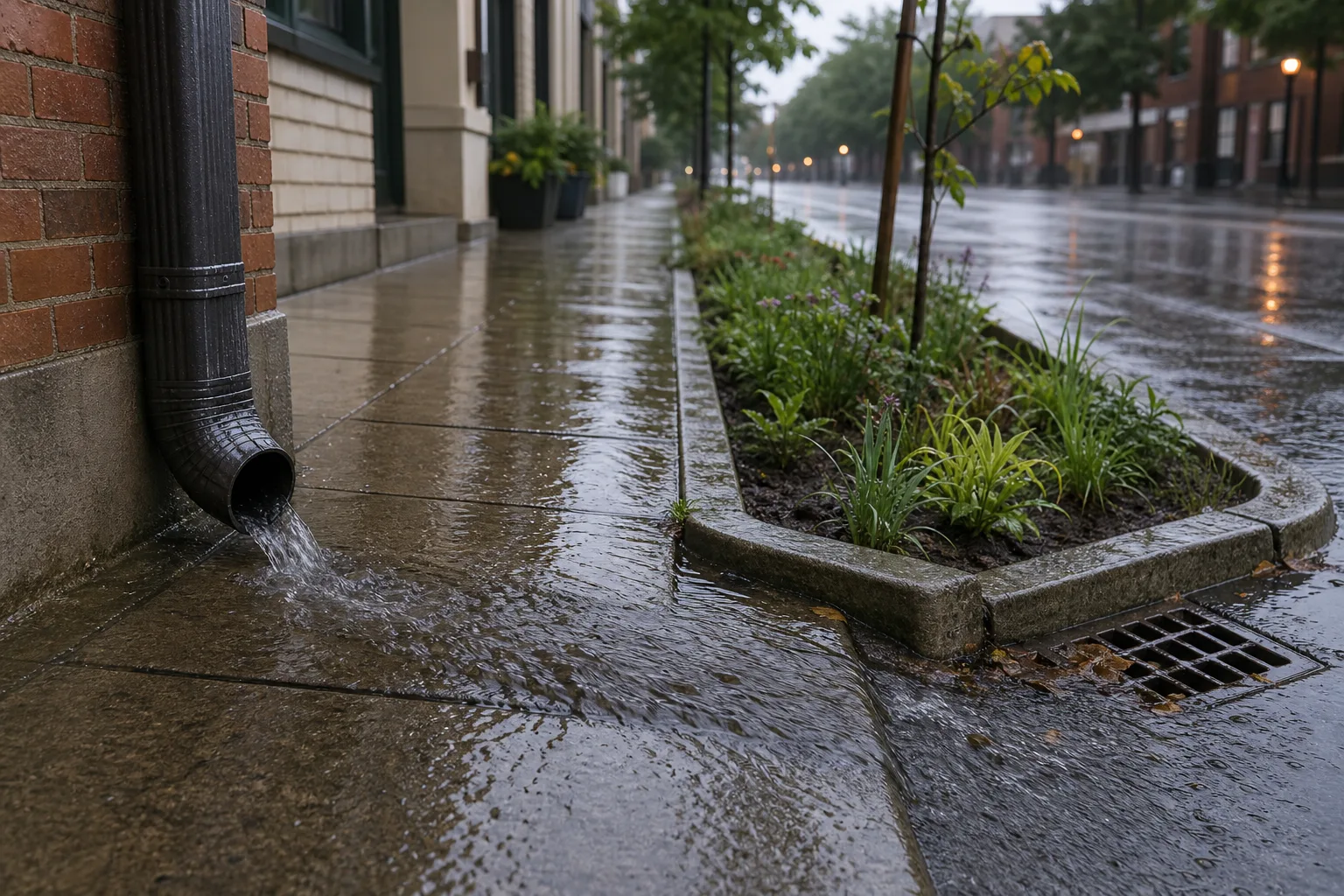
A downpipe can send roof water across a paved path, past a nearby drain and towards a lower kerb. Tracing the rain route across a city block helps you record that visible movement without guessing what happens underground.
Roof outlets show where runoff begins
Gutters collect rain from a roof and carry it towards downpipes. A visible outlet may empty into a storage tank, onto paving or into a planted area; if a pipe disappears below ground, its destination is not visible.
On a simple sketch, mark each outlet and draw only the surface route you can see. Keep buried connections labelled as unknown, so a building manager or drainage professional can distinguish observation from assumption.
Hard surfaces guide water along slopes and kerbs
Asphalt, concrete and tightly laid paving tend to carry water across their surfaces. Slopes, kerbs and low points can guide it towards a planted strip, street channel or inlet, sometimes past a drain that looks close by.
Permeable paving has openings intended to let water pass into a prepared base. What happens next depends on the base, soil, maintenance and drainage design, so the surface alone cannot show whether water soaks in or travels elsewhere.
A lowered kerb can offer a route from the street into planting, while a raised kerb may keep runoff moving along the road. Both direct water; neither, by itself, explains where the full drainage system leads.
Soil and planting change the visible route
Soil texture, structure, moisture and slope influence how rain enters the ground. Compacted or already wet soil may take water in slowly, and grass can conceal compacted ground beneath it.
A rain garden is a shallow planted area designed to receive runoff. Its suitability depends on the water source, site conditions, drainage arrangements and route for excess water. Before proposing one or changing drainage, check with the relevant local authority or a qualified drainage professional; requirements and suitable designs vary by site.
Say a courtyard downpipe empties onto a concrete path and the owner is considering a planted basin. They ask a qualified professional to assess the proposed location and overflow route, then follow the site-specific plan. During rain, they can observe whether water enters the planting and whether excess follows the planned route; those observations inform the next conversation, but do not establish that the same design suits another site.
Puddles show where water gathers, not why
Runoff may collect at a low point when it arrives faster than the ground, storage areas or drainage system can receive it. A blocked inlet or connected stretch of hard paving may contribute, but a puddle’s location alone cannot identify the cause.
Observe ordinary rain from a safe place and note the visible route. Do not lift drain covers or enter drainage structures. Report recurring blockages or water entering a building to the responsible property manager, utility or local authority.
What does a rain route across a city block tell you?
Does rain always flow to the nearest drain?
No. Slopes, kerbs and other barriers can guide water past a nearby inlet towards a lower point. Follow the visible surface rather than judging the route by distance.
How does permeable paving differ from a rain garden?
Permeable paving lets water through openings into a prepared base, while a rain garden is a planted depression designed to receive runoff. Site conditions and overflow arrangements affect whether either option is suitable.
Can a rain barrel prevent street flooding?
A rain barrel stores roof runoff when it has capacity, but it cannot address every source of street flooding. Its overflow needs a route that is suitable for the particular site, so check the plan with an appropriate local authority or professional before making changes.
Why might water run off a lawn?
The underlying soil may be compacted, wet, sloped or slow to absorb water. Grass cover does not reveal the condition of the soil beneath it.
Make a surface sketch that leads to useful next steps
Walk the route in dry weather, then observe from a safe place during ordinary rain. Stay out of the road and away from fast-moving water. Record what you can see and use each observation to decide what to ask or report.
- Downpipe outlet: If it visibly ends at a tank or planted area, mark that destination; if it disappears underground, mark the connection unknown and ask for a drainage plan before proposing a change.
- Paving slope: If the surface clearly falls towards a kerb or inlet, draw an arrow in that direction; if the direction is unclear, mark it uncertain and observe again from a safe position rather than choosing a route.
- Ground cover: If soil or planting visibly receives runoff, mark it as a possible receiving surface; if paving is sealed, trace the surface flow to the next visible low point instead.
- Kerb opening: If a lowered section opens into planting, record it as a possible route; if the kerb is raised, follow the street-side channel and do not assume water enters the planted area.
- Street inlet: If leaves or litter appear to cover it, report a possible blockage; if it looks clear, note only that the opening is visible and do not infer that the buried system is working.
- Water at a low point: If it repeatedly gathers there, record the location and report persistent flooding; if it drains away, keep the sketch as an observation rather than a diagnosis.
- Route near a doorway: If water approaches an entrance, record the route and contact the building manager or relevant authority; if it does not, continue observing without changing drainage based on one rain event.
Imagine you are sketching a block with a downpipe that empties onto a sloped paved path, a lowered kerb beside a planted strip and a street inlet. Starting with those three visible features, draw an arrow from the outlet along the path, mark the buried pipe connection as unknown, and watch ordinary rain from a safe spot. If water enters the planted strip, record that surface route; if it crosses towards a doorway instead, add that observation and ask the building manager or a qualified drainage professional to assess the site before any alteration. In either case, the sketch describes what you saw, not what the underground system does.
Check site conditions before changing a drainage route
Redirecting a downpipe, changing paving or adding a rain garden can send water towards a building or neighbouring land if the route is unsuitable. Rain barrels, permeable paving and planted basins serve different purposes, and their suitability depends on site conditions and local requirements.
- Outlet destination: If it visibly feeds a tank, record that route for the property manager; if it points towards a foundation or disappears underground, pause and seek site-specific advice before redirecting it.
- Receiving ground: If a qualified assessment says the proposed area suits the intended runoff, discuss the proposed planting; if it is persistently waterlogged or its condition is unclear, do not dig until the site is assessed.
- Overflow route: If the plan shows where excess water can go without threatening buildings or neighbouring land, include that route in the discussion; if it would cross a doorway or boundary, revise the proposal with an appropriate professional before proceeding.
- Paving and buried connections: If the proposed route and relevant connections are confirmed, check the plan against local guidance; if services or connections are unknown, have them identified before work.
- Ownership and local requirements: If permission and responsibility are clear, follow the applicable requirements; if either is uncertain, contact the property manager or local authority before arranging work.
- Leaves and sediment: If debris is on an accessible surface you are responsible for, clear it safely; if it is in a public drain or unsafe to reach, report it rather than trying to clear it.
For recurring flooding, work near a building or buried utilities, or an uncertain connection, seek advice from the relevant authority or a qualified drainage professional. This keeps a useful observation separate from a design decision that needs a site-specific assessment.
Keep the sketch centred on what you can observe
A rain route across a city block links roof outlets, paving, planted areas, slopes and drains, while some connections remain hidden. A clear sketch distinguishes visible surface flow from unknowns and gives a building manager, local authority or drainage professional a focused starting point.
Record where water begins, which surfaces guide it and where it gathers or enters planting. That practical record can make the next discussion more useful: it shows the route you observed and identifies the precise connection or site condition that still needs checking.